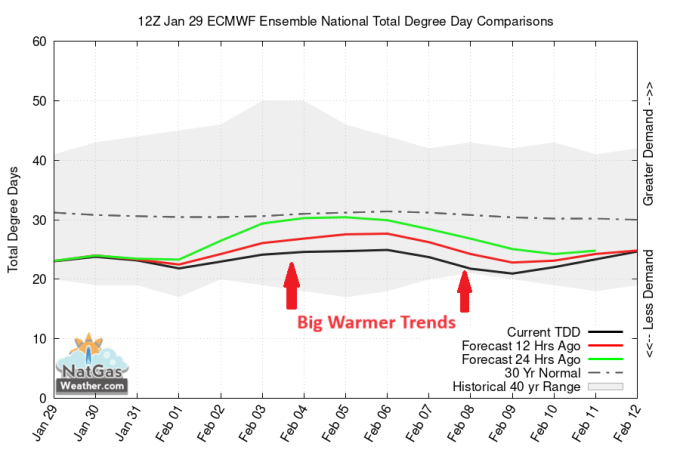
US natural gas prices (NGG24), (NGH24), (KOLD), (UNG) sold off Monday after big warmer trends the past 30-hours and where both the mainstay GFS and ECMWF weather models shed a hefty 30+ Heating Degree Days (HDDs) for the coming 15-days. The weekend weather data had trended colder with a weather system into the eastern US this coming weekend but reversed course overnight and midday by seeing much less subfreezing air into the northern US. And it didn't help the pattern for Feb 8-13 also lost demand as warmer than normal upper high pressure sets up over the eastern ½ of the US, while forecast in recent data to be stronger and last longer, thereby preventing cooler weather systems into the western and central US from advancing into the important eastern US.
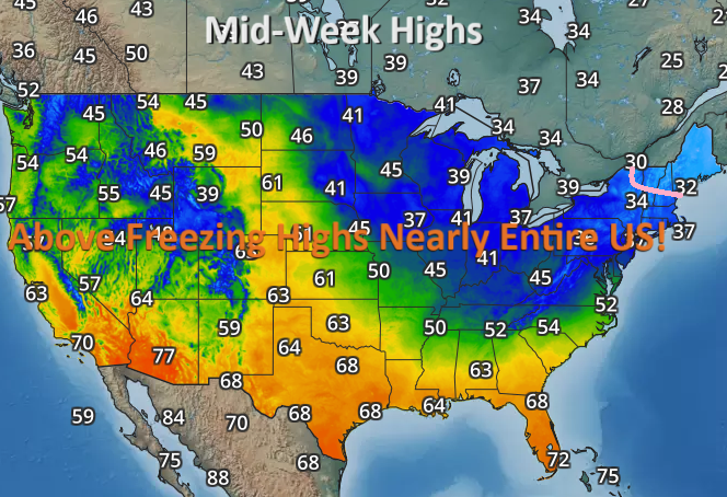
The reason for such light national demand the next 15-days is the lack of subfreezing high temperatures over most the US most days (image below). With highs of 50s to 80s over much of the southern US, and with highs of 30s to 50s over the northern US, late January and early February is proving to be one of the warmest of the past 50-years, just like much of the month of December.

The weather pattern the next several days will be dominated by a much warmer than normal ridge of high pressure, leading to very little coverage of subfreezing highs (image above and below). The southern US will be very comfortable with highs of upper 50s to lower 80s, including comfortable highs of 60s up the central Plains. The only relatively cold area of the country the next 5-days will be New England w/highs near 30F (image below).
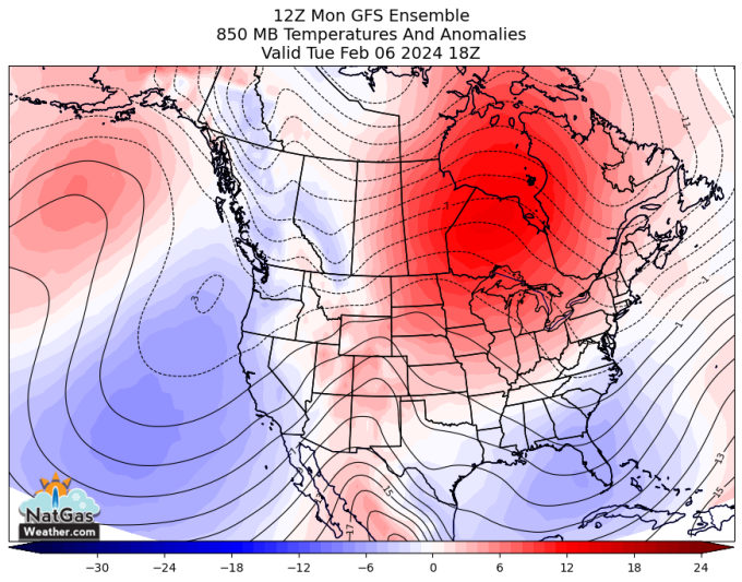
Next week's weather pattern continues with a much warmer than normal ridge dominating much of the interior US (image below), resulting in warmer than normal temperatures and continued lighter than normal national demand. There will be weather systems into the western and southern US with rain and snow, but rather mild and with little subfreezing air. A cooler system will impact the New England.
Much of the weather data favors cooler vs normal temperatures gradually spreading across the US Feb 15-23 for stronger national demand (image below). However, the risk is the Feb 14-16 period trends warmer in time, just as the Feb 10-13 period did, with the reason again being a warm ridge over the eastern 1/2 of the US holding stronger and longer. There's also risks that when colder temperatures finally arrive after Feb 14-15, there arrive not as impressively cold.

In summary, natural gas prices opened the week with fresh selling, aided by big warmer trends for the first 13-days of February for much lighter than normal HDDs and national demand. A cooler pattern is forecast in most of the weather models for Feb 15-25, although the risk is a warm eastern US ridge holds stronger and longer and a cooler pattern gets delayed again and then arrives with less subfreezing air.
For the latest weather forecasts and weather statistics specific to the natural gas markets and energy industry, visit us at www.natgasweather.com.
On the date of publication, NatGasWeather.com did not have (either directly or indirectly) positions in any of the securities mentioned in this article. All information and data in this article is solely for informational purposes. For more information please view the Disclosure Policy here.
Disclaimer: The copyright of this article belongs to the original author. Reposting this article is solely for the purpose of information dissemination and does not constitute any investment advice. If there is any infringement, please contact us immediately. We will make corrections or deletions as necessary. Thank you.