Natural gas prices ((NGG24) , (NGH24) , (BOIL) , (UNG) rocketed higher the past couple sessions after colder trends with frigid blasts into the US for Jan 14-21. In fact, the weather models viewed the coming cold shots as being relatively modest to start the week. That was until rapidly trending colder the past few days by seeing subfreezing air advancing more aggressively into the southern US, especially Texas. While there's impressive bouts of subfreezing air set to invade the US Jan 14-21, it comes only after a near record warm December and steady warmer trends for the first 10-days of January. And while December was warm and cold failed to come through for Jan 1-10, natural gas prices shrugged these bearish elements off traded higher over the past 3-weeks. The past two sessions, prices rocketed further higher and at a more extreme pace as weather patterns were trending cold enough to finally intimidate for the first time this winter season. So, just how cold is this coming frosty blast? And how long will it last?
Currently, there's a strong weather system tracking across the eastern US w/rain and snow. Out ahead of this storm, temperatures have been near to warmer than normal over the southern and eastern US and where highs have been mostly mild w/highs of mid-40s to 70s, and where they will remain for a few more days. Beacuse of this, national demand will be uneventful through Thursday and despite chilly highs of 0s to 30s over the Rockies and N. Plains.
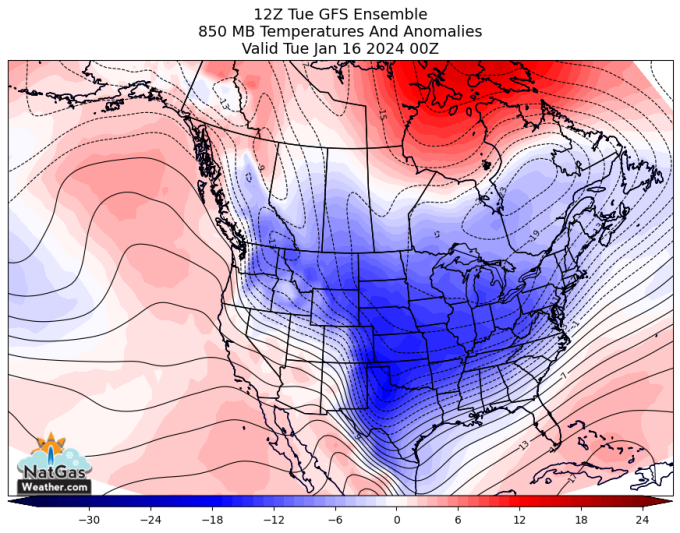
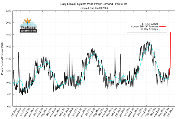
Frigid air over SW Canada will advance aggressively across the US this weekend through next week w/lows of -10s to 20s over much of the northern ⅔ of the US and why national demand will reach the strongest levels so far this winter. Demand will be aided by hard freezes into Texas and the South w/lows of teens to 30s.

Wind Energy Generation across ERCOT will be strong the next few days. However, as subfreezing air advances into Texas next week, cities such as Dallas are likely to see lows in the teens and 20s. And with cold occurring with modest wind energy generation, demand will be strong across ERCOT.
Also of interest, freeze-offs are expected over the Rockies and surrounding lower elevation plays due to cold conditions and with current estimates of 3-4 Bcf/day production losses for a few days.
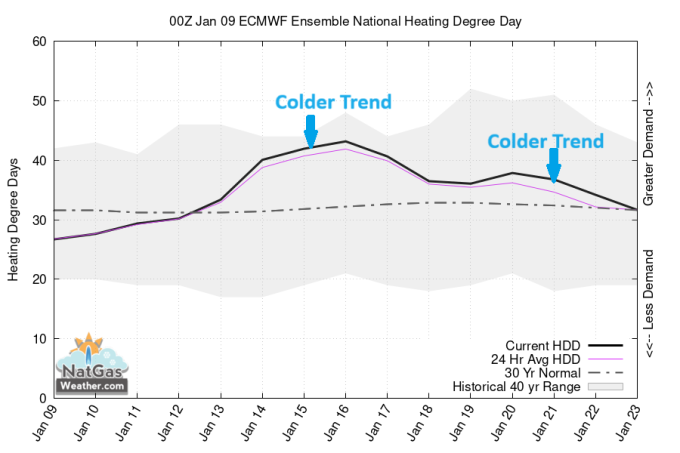
The weather data trended colder Jan 19-21 by lingering subfreezing air across the northern US stronger and longer (image below). Thereafter, much of the weather data favors temperatures moderating over the US Jan 22-25, although this has been delayed a few days. And the risk is dense cold air is stubborn to erode and lingers further and past Jan 21

The theme the past month has been colder trends/bullish news moves the needle stronger than warmer trends/bearish news that garners little price reaction, or if selling does it occur, it immediately gets bought. And now with a frosty cold shot into the US coming for next week, natural gas prices (NGG24) ((NGG24) , (NGH24) , (BOIL) , (UNG) have spiked the past two sessions, including front month Feb'24 contracts from $3.40 to. $2.69 in just 2-sessions. Going forward, weather risks are colder air lingers longer than the weather models currently expect, stalling a warmer US pattern from gaining ground until after Jan 21. Regardless, natural gas traders need to be on their toes the rest of the week since price action is likely to remain volatile and with daily swings of 20-30¢ cents likely, driven by large run-to-run weather model trends.
For the latest weather forecasts specific to the natural gas markets, as well as real-time updating weather model statistics and trends, visit us at www.natgasweather.com
On the date of publication, NatGasWeather.com did not have (either directly or indirectly) positions in any of the securities mentioned in this article. All information and data in this article is solely for informational purposes. For more information please view the Disclosure Policy here.
Disclaimer: The copyright of this article belongs to the original author. Reposting this article is solely for the purpose of information dissemination and does not constitute any investment advice. If there is any infringement, please contact us immediately. We will make corrections or deletions as necessary. Thank you.